Buttermilk
None of 5 lifts running right now
Model forecastStrong gusts today · 52 mph
Most on Thu 26, 4 in · Snow to the base · Upper mountain · Full forecast
Checked at 5:18 AM · 5:18 AM local time · from aspensnowmass.com
Buttermilk webcams
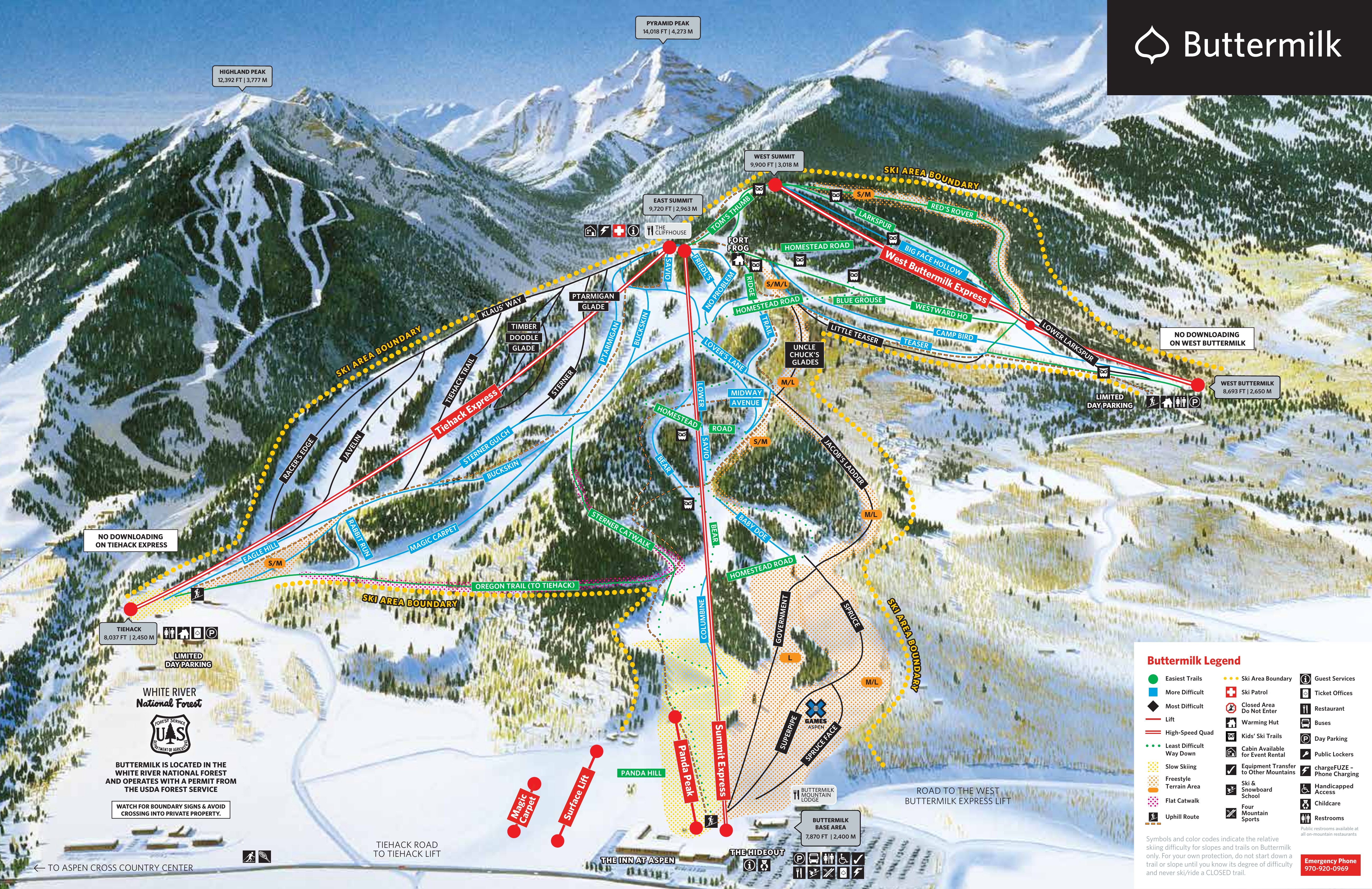
Map
Maps
Vertical drop: 2,001 ft verticalBase 7,881 · Top 9,882 ft#220 of 318 on status.live
Buttermilk snow report and forecast
Snow is a model estimate, not measured.
- Today17Light snow1 in54°30°
- Tomorrow18Cloudy43°27°
- Thu19Cloudy48°27°
- Fri20Snow showers1 in39°23°Snow to the base
- Sat21Light snow71%34°19°
- Sun22Mostly clear46°21°
- Mon23Snow2 in39°25°Snow to the base
- Tue24Snow1 in32°14°Snow to the base
- Wed25Snow1 in34°12°Snow to the base
- Thu26Snow showers4 in30°9°Snow to the base
Source: Open-Meteo (CC BY 4.0), model forecast; temperatures and conditions are for the base, 7,871 ft, snow for the upper mountain, 9,882 ft.
Roads
checked 5:21 AM- CO-82closed · Between County Road 23 (8 miles east of the Aspen area) and Carlton Tunnel Road (11 miles west of the Twin Lakes area) from Mile Point 51.4 to Mile Point 68.5. Road closed expect delays due to safety concerns. Comment: Due to forecasted winter weather, the Colorado Department of Transportation, in partnership with the Colorado Avalanche Information Center, will close Colorado Highway 82 over Independence Pass between Aspen and Twin Lakes beginning at 8 a.m. on Saturday, October 31. The incoming storm is expected to bring snow accumulation and strong winds, making travel across the high-mountain pass hazardous. Conditions will be re-evaluated once the storms pass to determine whether the road can reopen for the fall or will enter its annual winter shutdown. CO 82 will be closed at approximately Lincoln Creek Road (Mile Point 51.1) on the west side and near Graham Gulch (MP 68.5) on the east side. The alternate route from the Denver Metro Area to Aspen is via westbound I-70 to Glenwood Springs, then CO 82 to Aspen.
Source: CDOT / COtrip
Buttermilk lift status
7,871 ft–9,882 ftAll 5 lifts closedShow
- Magic CarpetClosed
- Panda PeakClosed
- Summit ExpressClosed
- Tiehack ExpressClosed
- West Buttermilk ExpressClosed
Source: aspensnowmass.com, the resort's own lift board, checked every few minutes.
About
Buttermilk Ski Area is a ski hill and an unincorporated community surrounding it in Pitkin County, Colorado. Located about halfway between the cities of Aspen and Snowmass Village, it is frequently considered the easiest skiing mountain in the area.
More about Buttermilk
Buttermilk has also been the host to the ESPN Winter X Games multiple times. It contains three ski areas: Tiehack (difficult), Main Buttermilk (regular), and West Buttermilk (easy). Art Pfister developed Buttermilk Mountain ski area in 1958.
Buttermilk is anchored by three high speed quads. The Summit Express services trails in the Main Buttermilk section of the mountain. The West Buttermilk Express, built in 2004, services beginner terrain on the west face of the mountain. The Tiehack Express, built in 2011, services advanced and intermediate terrain on the west face of Buttermilk Mountain. Buttermilk is known as one of the best beginner mountains in North America, to learn ski or snowboard. Its base includes The Hideout — an integrated play-and-learning area for children in ski school ages 2 ½ to 6 years old.
In February 2014, Nancy Pfister was found brutally murdered in a walk-in closet of her home in Buttermilk. The case made headlines across the country, and has been featured on Dateline and Snapped.
From Wikipedia: Buttermilk (ski area), CC BY-SA 4.0.
Ski area
- Green 8.6 mi
- Blue 9.2 mi
- Black 7.1 mi
Counted from the runs and lifts mapped in OpenStreetMap, by OpenSkiMap; © OpenStreetMap contributors. Resorts count their own way (trails, acres), so their figures can differ.
Road and nearby webcams
CDOT / COtrip
Getting there
Nearby resorts
Ask Claude or ChatGPT "Is Buttermilk open today?" with status.live connected. How to connect