Hintertux Glacier
12 de 21 remontes en marcha
Pronóstico del modeloLluvia en la base, nieve por encima de 2,250 m
Máximo el jue 19 y jue 26, 5 cm · Rain at the base mar 17 and jue 19 · Parte alta · Pronóstico completo
Comprobado a las 12:12 PM · 12:12 PM hora local · de winter.intermaps.com
Cámaras de Hintertux Glacier
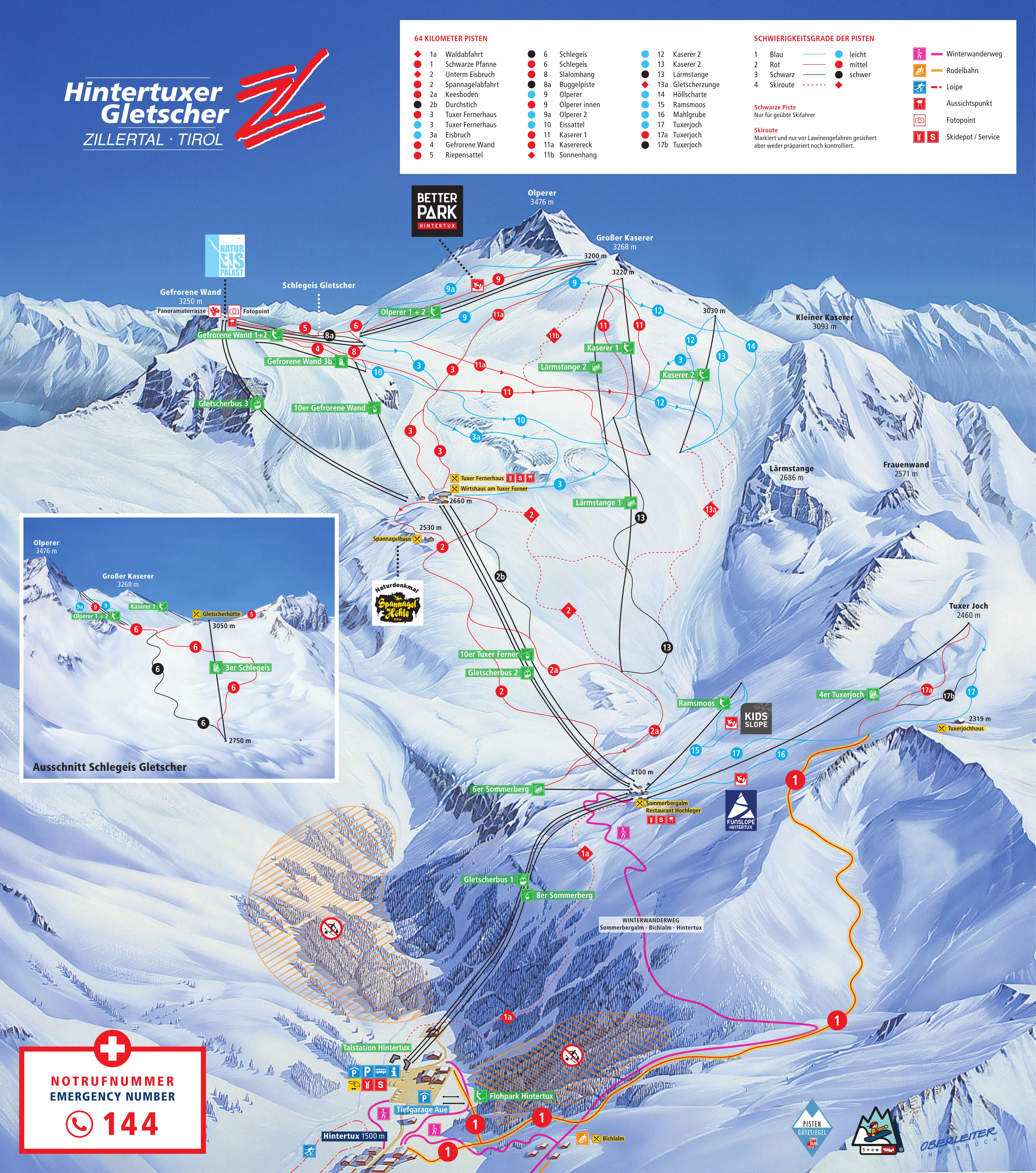
Mapa
Mapas
Mapa 3D beta
Muestra tu ubicación en la montaña
Desnivel: 1,745 m de desnivelBase 1,500 · Cima 3,245 m#29 de 318 en status.live
Remontes de Hintertux Glacier
1,500 m–3,253 mAbierto · 12
- 6er SommerbergAbierto
- 6er Lärmstange 2Abierto
- Kaserer 1Abierto
- Kaserer 2Abierto
- RamsmoosAbierto
- Babylift GletscherbodenAbierto
- Gletscherbus 1Abierto
- Gletscherbus 2Abierto
- Gletscherbus 3Abierto
- 8er SommerbergAbierto
- 4er FernerhausAbierto
- 10 EUB Gefrorene WandAbierto
Programado · 4
- Gefrorene Wand 1Programado
- Gefrorene Wand 2Programado
- Olperer 1Programado
- Olperer 2Programado
5 cerradosMostrar
- 2er Gefrorene Wand 3bCerrado
- 3er SchlegeisCerrado
- 4erTuxerjochCerrado
- 6er Lärmstange 1Cerrado
- Babylift HintertuxCerrado
Fuente: winter.intermaps.com, tablero de remontes de la estación, comprobado cada pocos minutos.
Pistas
13 of 32 open · 45.5 of 80.5 kmAbierto · 13
- Run 3AzulAbierto
- 9 Olperer 1Azul3.5 kmAbierto
- 9a Olperer 2Azul2.0 kmAbierto
- Run 10AzulAbierto
- 12 HöllscharteAzul8.0 kmAbierto
- 15 RamsmoosAzul1.0 kmAbierto
- 2 SpannagelabfahrtRoja4.5 kmAbierto
- 3 Tuxer FernerhausRoja8.0 kmAbierto
- 5 RiepensattelRoja5.0 kmAbierto
- 8 SlalomhangRoja4.5 kmAbierto
- 9 Olperer innenRojaAbierto
- 11 KasererRoja6.0 kmAbierto
- 11a KaserereckRoja3.0 kmAbierto
19 cerradosMostrar
- Run 3aAzulCerrado
- Run 13AzulCerrado
- Run 14AzulCerrado
- 16 MahlgrubeAzul3.0 kmCerrado
- 17 TuxerjochAzul5.0 kmCerrado
- 1 Schwarze PfanneRoja7.0 kmCerrado
- 2a MoräneRoja3.0 kmCerrado
- 4 Gefrorene WandRojaCerrado
- 6 SchlegeisRojaCerrado
- 17a TuxerjochRoja0.5 kmCerrado
- Run 2bNegraCerrado
- 6 SchlegeisNegraCerrado
- 8a BugglpisteNegra1.0 kmCerrado
- Bergtour ZittauerhütteNegraCerrado
- 1a WaldabfahrtRuta de esquí3.0 kmCerrado
- 2 Unterm EisbruchRuta de esquí3.0 kmCerrado
- 11b SonnenhangRuta de esquí1.0 kmCerrado
- 13 GletscherzungeRuta de esquí5.0 kmCerrado
- 13a HaxenbrecherRuta de esquí3.5 kmCerrado
Misma fuente y actualización que los remontes anteriores.
Acerca de
The Hintertux Glacier (German: Hintertuxer Gletscher) is the tourist name for the glaciers of the Gefrorene-Wand-Kees, also called the Tuxer Ferner, and the nearby Riepenkees at the top of the Tuxertal, a side valley of the Zillertal in the Austrian state of Tyrol. At its highest point the ski region reaches a height of 3,250 m (10,660 ft) in the saddle between the peaks of the Gefrorene-Wand-Spitzen.
More about Hintertux Glacier
Both glaciers can be accessed by gondola and chair lifts.
De Wikipedia: Hintertux Glacier, CC BY-SA 4.0.
Dominio esquiable
Figures for the ski area as mapped: Hintertuxer Gletscher.
- Azul 17 km
- Roja 25 km
- Negra 2.9 km
- Otros 1.2 km
Calculado con las pistas y remontes de OpenStreetMap, mediante OpenSkiMap; © colaboradores de OpenStreetMap. Cada estación cuenta de manera diferente; sus cifras pueden variar.
Nieve y pronóstico de Hintertux Glacier
Espesor de nieve medido por avalanche.report a las its Wandspitze Schneestation, 1.9 km from the resort, hoy; nieve medida en terreno llano, no en pistas. Los demás valores son estimaciones del modelo.
- Hoy17Chubascos1 cm9°4°Lluvia en la base, nieve por encima de 2,250 m
- Mañana18Chubascos1 cm6°2°
- jue19Chubascos de nieve5 cm6°2°Lluvia en la base, nieve por encima de 1,750 m
- vie20Lluvia ligera1 cm5°1°
- sáb21Chubascos de nieve2 cm2°-3°
- dom22Nublado39%1°-4°
- lun23Nieve ligera3 cm0°-3°Nieve hasta la base
- mar24Niebla20%4°-4°
- mié25Chubascos de nieve1 cm4°-4°
- jue26Chubascos de nieve5 cm2°-3°Nieve hasta la base
Fuente: Open-Meteo (CC BY 4.0), pronóstico del modelo; temperatura y tiempo en la base, 1,500 m, nieve en la parte alta, 3,253 m.
Cámaras de carreteras y cercanas
windy.com
Cómo llegar
Estaciones cercanas
Pregunta a Claude o ChatGPT «¿Está abierto Hintertux Glacier hoy?» con status.live conectado. Cómo conectarlo