Katschberg
None of 16 lifts running right now
Model forecastStrong gusts today · 85 km/h
Most on Thu 19 and Thu 26, 5 cm · Base · Full forecast
Checked at 12:41 PM · 12:41 PM local time · from katschberg.at
Katschberg webcams
2 · swipeMap
Maps
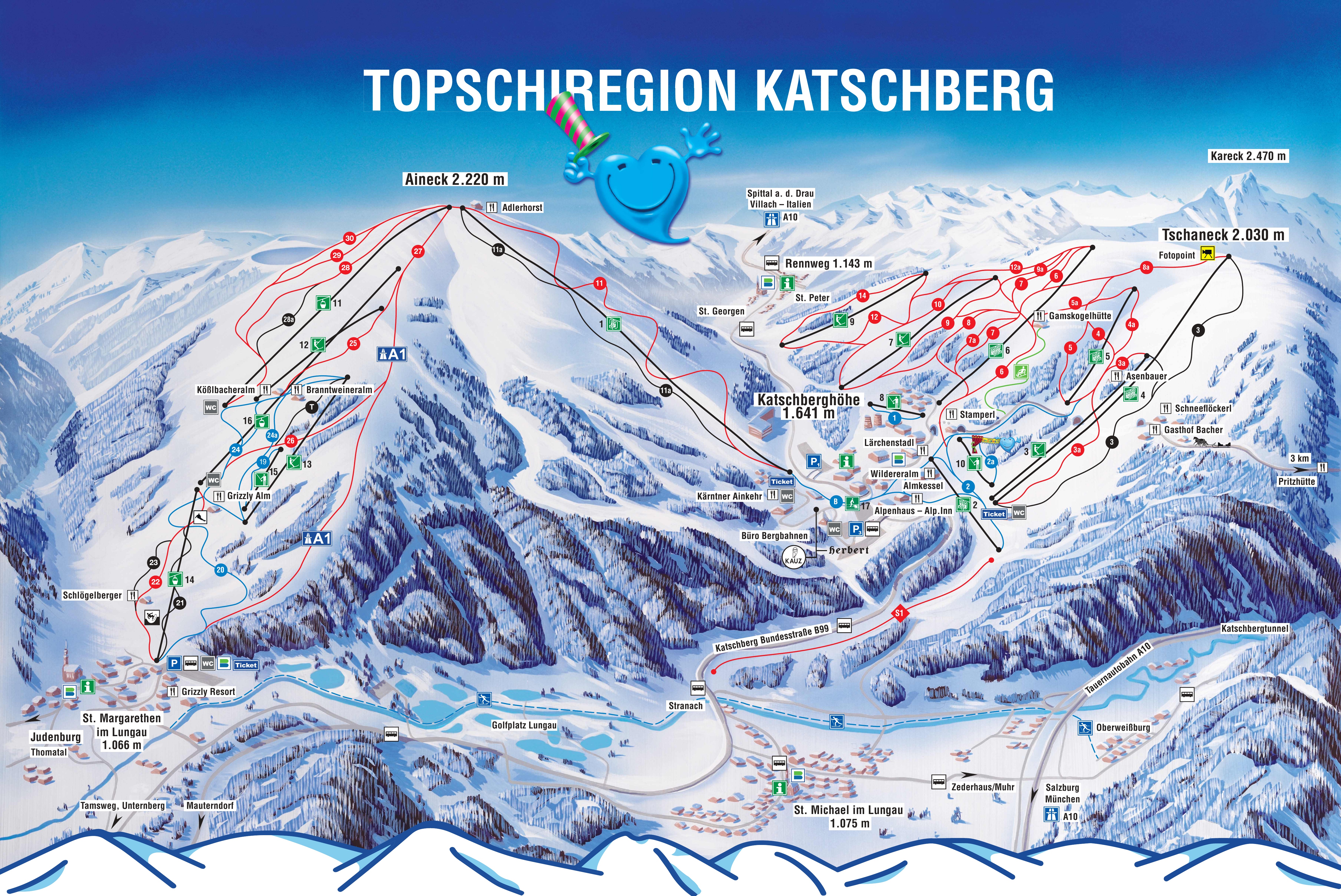
3D map beta
Shows where you are on the mountain
Vertical drop: 1,157 m verticalBase 1,054 · Top 2,211 m#95 of 318 on status.live
Katschberg snow report and forecast
Snow is a model estimate, not measured.
- Today17Light rain35%3°-1°
- Tomorrow18Rain showers23%5°0°
- Thu19Snow showers5 cm1°-2°
- Fri20Cloudy3°-1°
- Sat21Cloudy20%2°-3°
- Sun22Fog1°-6°
- Mon23Fog1°-9°
- Tue24Cloudy3°-8°
- Wed25Fog40%4°-8°
- Thu26Heavy snow5 cm3°-4°
Source: Open-Meteo (CC BY 4.0), model forecast; temperatures and conditions are for the base, 1,646 m.
Katschberg lift status
All 16 lifts closedShow
- 2 KönigswiesenbahnClosed
- 3 BärenwiesenliftClosed
- 5 SonnalmbahnClosed
- 7 FreibergliftClosed
- 8 TellerliftClosed
- 9 SonnleitenliftClosed
- 10 Mini-JetClosed
- 11 GipfelbahnClosed
- 12 AineckliftClosed
- 13 BranntweinerliftClosed
- 15 Kids JetClosed
- 16 Silverjet 2Closed
- 14 Silverjet 1Closed
- 1 AlmbahnClosed
- 4 TschaneckbahnClosed
- 6 GamskogelexpressClosed
Source: katschberg.at, the resort's own lift board, checked every few minutes.
Runs
0 of 36 open · 0.0 of 64.9 kmAll 36 runs closedShow
- 1 Übungshang TellerliftBlue0.5 kmClosed
- 2 Übungshang KönigwieseBlue0.9 kmClosed
- 2a Katschis KinderweltBlue0.5 kmClosed
- 19 Übungshang AineckBlue0.6 kmClosed
- 20 FamilienabfahrtBlue4.7 kmClosed
- 24 BranntweinerabfahrtBlue2.1 kmClosed
- 24a Branntweiner ÜbungshangBlueClosed
- B Verbindungsbrücke KatschbergBlue0.4 kmClosed
- 3a BärenwiesenpisteRed1.5 kmClosed
- 4 Sonnalmpiste NordRed1.5 kmClosed
- 4a KalkmuldeRed0.8 kmClosed
- 5 Sonnalmpiste SüdRed1.5 kmClosed
- 6 Gamskogelpiste NordRed2.2 kmClosed
- 7 Gamskogelpiste SüdRed2.1 kmClosed
- 7a Trainingspiste KatschbergRed1.3 kmClosed
- 8 Abfahrt Tschaneck über KönigswieseRed4.2 kmClosed
- 9 Freibergpiste NordRed1.8 kmClosed
- 10 Freibergpiste SüdRed1.4 kmClosed
- 11 Abfahrt vom AineckRed4.8 kmClosed
- 12 Sonnleiten NordRed3.1 kmClosed
- 14 Sonnleiten SüdRed2.0 kmClosed
- 22 SchwaigabfahrtRed2.7 kmClosed
- 25 AlmenabfahrtRed1.8 kmClosed
- 26 SandrieserabfahrtRed3.6 kmClosed
- 27 HochfeldabfahrtRed1.4 kmClosed
- 28a KarabfahrtRed3.1 kmClosed
- 29 SnowbowleRed1.0 kmClosed
- 30 SnowbowleRed2.1 kmClosed
- A1 A1 PisteRedClosed
- S1 PisteRedClosed
- 3 TschaneckpisteBlack1.9 kmClosed
- 11a DirettissimaBlack3.2 kmClosed
- 21 NordabfahrtBlack2.3 kmClosed
- 23 WildparkabfahrtBlack1.4 kmClosed
- 28 Kar-SteilhangBlack1.0 kmClosed
- T Trainingspiste AineckBlack1.5 kmClosed
Same source and update time as the lifts above.
Ski area
Figures for the ski area as mapped: Katschberg-Aineck.
- Blue 11 km
- Red 35 km
- Black 5.9 km
Counted from the runs and lifts mapped in OpenStreetMap, by OpenSkiMap; © OpenStreetMap contributors. Resorts count their own way (trails, acres), so their figures can differ.
Road and nearby webcams
windy.com
Getting there
Nearby resorts
Ask Claude or ChatGPT "Is Katschberg open today?" with status.live connected. How to connect