Palisades Tahoe
None of 39 lifts running right now
Most on Thu 19, 23 in · Rain at the base Wed 25 · Upper mountain · Full forecast
Checked at 3:54 AM · 3:54 AM local time · from palisadestahoe.com
Palisades Tahoe webcams
7 · swipeMap
Maps
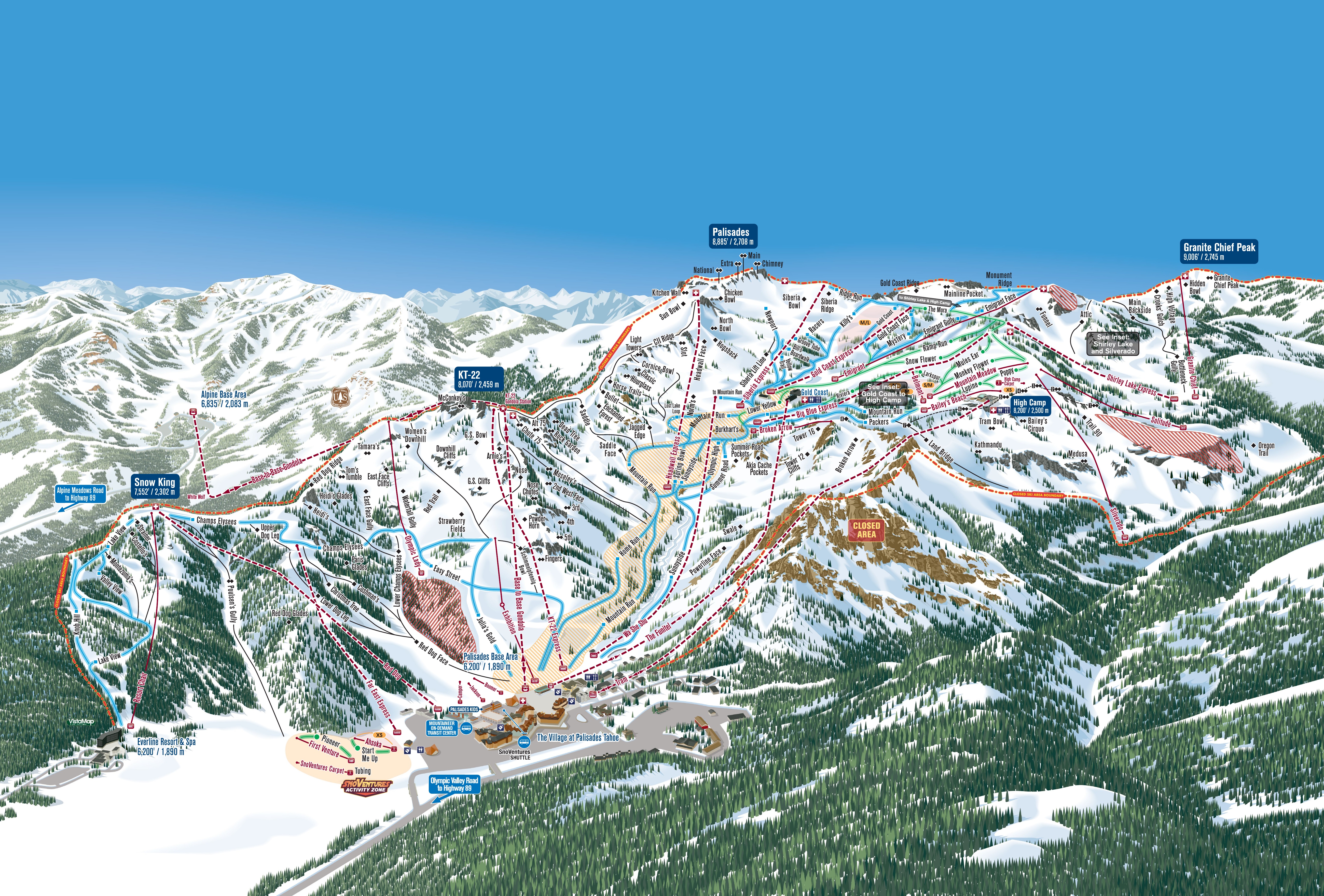
3D map beta
Shows where you are on the mountain
Vertical drop: 2,543 ft verticalBase 6,201 · Top 8,743 ft#181 of 318 on status.live
Palisades Tahoe snow report and forecast
Snow is a model estimate, not measured.
- Today17Cloudy32°19°
- Tomorrow18Heavy snow22 in36°21°Snow to the base
- Thu19Heavy snow23 in32°25°Snow to the base
- Fri20Snow73%32°5°
- Sat21Heavy snow3 in32°5°Snow to the base
- Sun22Heavy snow7 in32°12°Snow to the base
- Mon23Snow2 in34°7°Snow to the base
- Tue24Snow showers6 in34°28°Snow to the base
- Wed25Heavy snow16 in36°30°Rain at the base until about 1 pm, then snow
- Thu26Snow showers4 in34°28°Snow to the base
Source: Open-Meteo (CC BY 4.0), model forecast; temperatures and conditions are for the base, 6,198 ft, snow for the upper mountain, 8,750 ft.
Roads
checked 3:53 AM- I-80R-2 · Chains or traction devices are required on all vehicles except four wheel / all wheel drive vehicles with snow-tread tires on all four wheels. Four wheel / all wheel drive vehicles must carry traction devices in chain control areas.
- SR-89R-2 · Chains or traction devices are required on all vehicles except four wheel / all wheel drive vehicles with snow-tread tires on all four wheels. Four wheel / all wheel drive vehicles must carry traction devices in chain control areas.
Source: Caltrans chain controls
Palisades Tahoe lift status
6,198 ft–8,750 ftAll 39 lifts closedShow
- Aerial TramClosed
- Alpine Bowl ChairClosed
- AhsokaClosed
- Base to Base Gondola to PalisadesClosed
- Bailey's BeachClosed
- Big CarpetClosed
- Base to Base Gondola to AlpineClosed
- KangarooClosed
- LakeviewClosed
- BelmontClosed
- Big Blue ExpressClosed
- MeadowClosed
- Broken ArrowClosed
- RoundhouseClosed
- ScottClosed
- Sherwood ExpressClosed
- EmigrantClosed
- ExhibitionClosed
- SubwayClosed
- Far East ExpressClosed
- Summit ExpressClosed
- First VentureClosed
- Treeline CirqueClosed
- YellowClosed
- FunitelClosed
- Gold Coast ExpressClosed
- Granite ChiefClosed
- Headwall ExpressClosed
- High Camp CarpetClosed
- KT-22 ExpressClosed
- Mountain MeadowClosed
- Olympic LadyClosed
- Red DogClosed
- Resort ChairClosed
- Shirley Lake ExpressClosed
- Siberia ExpressClosed
- SilveradoClosed
- SolitudeClosed
- Wa She ShuClosed
Source: palisadestahoe.com, the resort's own lift board, checked every few minutes.
About
Palisades Tahoe is a ski resort in the Western United States, located in Olympic Valley, California, northwest of Tahoe City in the Sierra Nevada range. Founded 77 years ago in 1949 as Squaw Valley, it changed its name in 2021 due to the derogatory connotations of the word "squaw".
More about Palisades Tahoe
It was the host site for the 1960 Winter Olympics.
The resort is the largest skiing complex in the Lake Tahoe region, and is known for its challenging terrain. Palisades Tahoe (not including Alpine Meadows) has a base elevation of 6,200 feet (1,890 m) and a skiable 3,600 acres (5.6 sq mi; 14.6 km²) across six peaks, employing 23 chairlifts, 4 carpet lifts, a tramway, a gondola connecting it to Alpine Meadows, and the only funitel in the United States. It tops out at 9,010 feet (2,746 m) at Granite Chief, and averages 400 inches (33.3 ft; 10.2 m) of annual snowfall. The resort attracts approximately 600,000 skiers a year, and is also home to several annual summer events.
The spotlight of the 1960 Olympics raised the resort's profile, and it went through several ownership changes beginning in the 1970s. In 2012, it merged with nearby Alpine Meadows, and became Squaw Valley Alpine Meadows, to offer joint access to 6,000 acres (9.4 sq mi; 24.3 km²), 43 lifts, and over 270 runs. However, a constructed gondola connection between the resorts, as well as a proposed development at its base, has met with controversy from environmentalists.
From Wikipedia: Palisades Tahoe, CC BY-SA 4.0. Opening year from Wikidata.
Ski area
Figures for the ski area as mapped: Palisades Tahoe Olympic Valley.
- Green 5.2 mi
- Blue 17 mi
- Black 19 mi
Counted from the runs and lifts mapped in OpenStreetMap, by OpenSkiMap; © OpenStreetMap contributors. Resorts count their own way (trails, acres), so their figures can differ.
Road and nearby webcams
Caltrans
Getting there
Nearby resorts
Ask Claude or ChatGPT "Is Palisades Tahoe open today?" with status.live connected. How to connect