Saas-Fee
5 of 23 lifts running
Model forecastRain at the base, snow above 2,350 m
Most on Thu 26, 49 cm · Rain at the base Tue 17 and Wed 18 · Upper mountain · Full forecast
Checked at 12:54 PM · 12:54 PM local time · from winter.intermaps.com
Saas-Fee webcams
2 · swipeMap
Maps
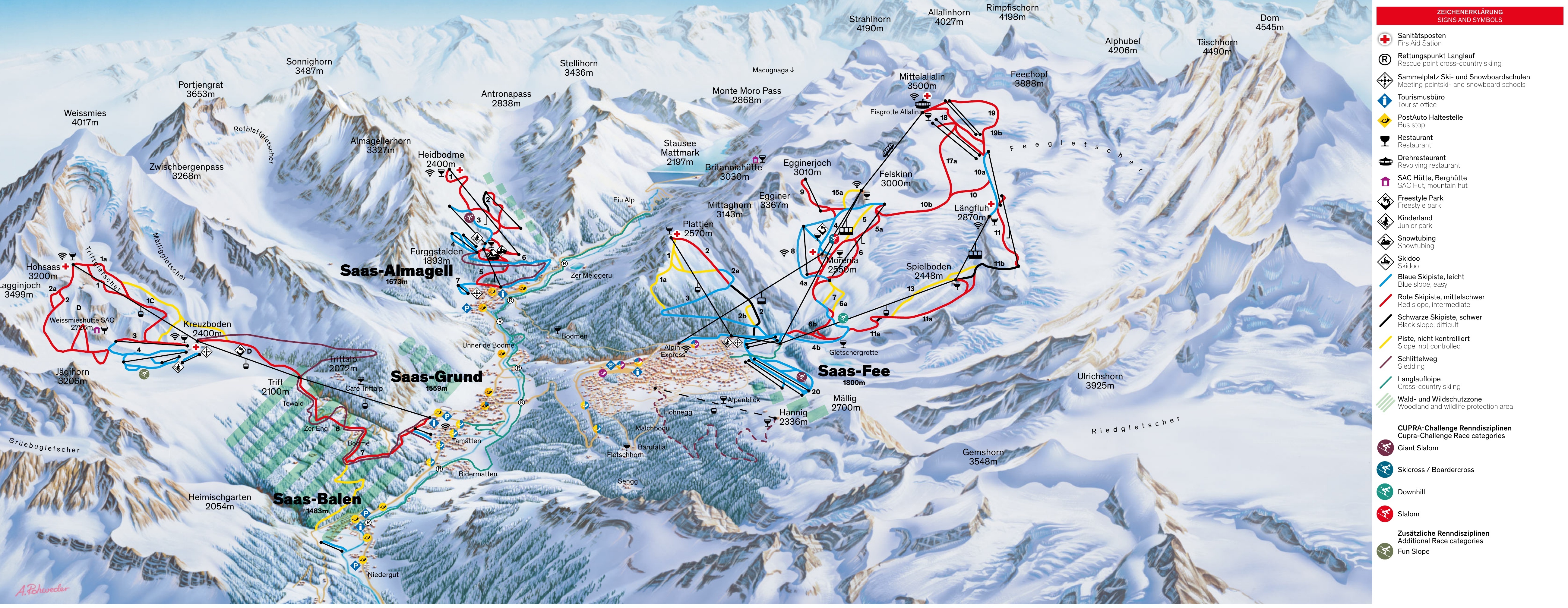
3D map beta
Shows where you are on the mountain
Vertical drop: 1,776 m verticalBase 1,780 · Top 3,556 m#28 of 318 on status.live
Saas-Fee lift status
1,780 m–3,561 mOpen · 5
- Metro AlpinOpen
- Alpin Express IIOpen
- FelskinnOpen
- MoreniaOpen
- SpielbodenOpen
18 closedShow
- Alpin Express IClosed
- PlattjenClosed
- E LeebodenClosed
- LängfluhClosed
- MittaghornClosed
- EgginerjochClosed
- PanoramaliftClosed
- Allalin 4/5Closed
- HannigClosed
- Längfluh SesselClosed
- Spielboden 2. SektionClosed
- Allalin 2Closed
- Stafelwald 1Closed
- Allalin 3Closed
- Bifig/Kalbermatten 1Closed
- Stafelwald 2Closed
- Bifig/Kalbermatten 2Closed
- Allalin 5Closed
Source: winter.intermaps.com, the resort's own lift board, checked every few minutes.
Runs
2 of 34 open · 6.5 of 100.0 kmOpen · 2
- 04a RitziRed3.5 kmOpen
- 05a EiskristallRed3.0 kmOpen
32 closedShow
- 02a WangBlue2.0 kmClosed
- 03 WaldwegBlue4.0 kmClosed
- 04 Egginer (2)Blue7.0 kmClosed
- 04 StollenausgangBlue1.0 kmClosed
- 04b GletschergrotteBlue6.0 kmClosed
- 04c SkiwegBlue0.2 kmClosed
- 08 MittaghornBlue1.0 kmClosed
- 10a Feechatz-PisteBlue5.0 kmClosed
- 20 StafelwaldBlue3.0 kmClosed
- KalbermattenBlue2.0 kmClosed
- 01 PlattjenRed2.0 kmClosed
- 02 Galen (red)Red3.5 kmClosed
- 05 FelskinnRed4.0 kmClosed
- 06 MoräneRed2.5 kmClosed
- 06b SperwerzuchtRed2.0 kmClosed
- 09 EgginerjochRed2.0 kmClosed
- 10 Weisse MeileRed2.0 kmClosed
- 10b GletscherbandRed5.0 kmClosed
- 11 LängfluhRed3.5 kmClosed
- 11a SpielbodenRed3.5 kmClosed
- 17a GletscherpromenadeRed4.0 kmClosed
- 18 MetroRed4.8 kmClosed
- 19 AllalinRed6.0 kmClosed
- 19b DerbyschussRed3.0 kmClosed
- 02 Galen (black)Black2.0 kmClosed
- 11b Oberer SpielbodenBlack2.5 kmClosed
- 01a NationalSki route2.0 kmClosed
- 02b GalenSki route1.0 kmClosed
- 06a KanonenrohrSki route1.0 kmClosed
- 07 Altes KanonenrohrSki route1.0 kmClosed
- 13 Weisse PerleSki route2.0 kmClosed
- 15a FelsentalSki route3.0 kmClosed
Same source and update time as the lifts above.
Roads
checked 12:50 PM- Stalden-Saas-Fee roadno closures or restrictions reported
Source: Federal Roads Office (FEDRO) Traffic Data Platform (TDP)
Ski area
- Blue 22 km
- Red 21 km
- Black 2.3 km
- Ski route 3.2 km
Counted from the runs and lifts mapped in OpenStreetMap, by OpenSkiMap; © OpenStreetMap contributors. Resorts count their own way (trails, acres), so their figures can differ.
Saas-Fee snow report and forecast
Snow depth measured by SLF (CC BY 4.0) at its Gibidum station, 2.5 km from the resort, today; snow on a flat field there, not on the pistes. Other snow figures are a model estimate.
- Today17Rain showers14 cm8°3°Rain at the base, snow above 2,350 m
- Tomorrow18Snow showers17 cm3°-1°Rain at the base until about 6 am, then snow
- Thu19Heavy snow18 cm2°-1°Snow to the base
- Fri20Snow showers6 cm0°-2°Snow to the base
- Sat21Snow showers5 cm2°-2°Snow to the base
- Sun22Light snow3 cm2°-3°Snow to the base
- Mon23Cloudy0°-5°
- Tue24Cloudy26%-1°-8°
- Wed25Heavy snow2 cm-1°-9°Snow to the base
- Thu26Heavy snow49 cm0°-5°Snow to the base
Source: Open-Meteo (CC BY 4.0), model forecast; temperatures and conditions are for the base, 1,780 m, snow for the upper mountain, 3,561 m.
Road and nearby webcams
windy.com
Getting there
Nearby resorts
Ask Claude or ChatGPT "Is Saas-Fee open today?" with status.live connected. How to connect