Sugarloaf
Aucune des 15 remontées ouverte actuellement
Maximum le jeu. 26, 3 in · Neige jusqu’en bas · Haut du domaine · Prévisions complètes
Vérifié à 7:08 AM · 7:08 AM heure locale · depuis sugarloaf.com
Webcams de Sugarloaf
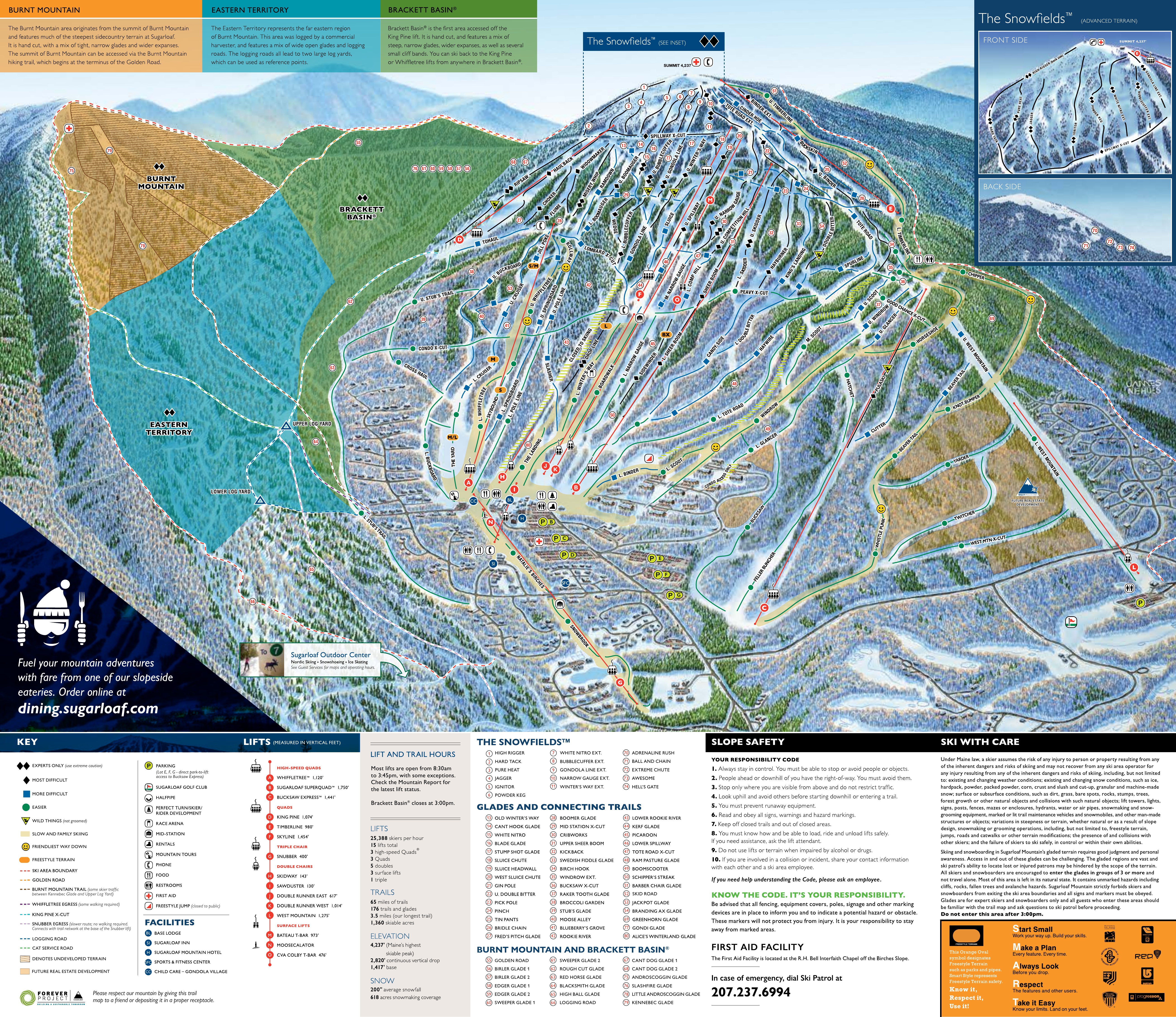
Carte
Cartes
Dénivelé : 2,769 ft de déniveléBas 1,394 · Sommet 4,163 ft#170 sur 318 sur status.live
Neige et météo à Sugarloaf
La neige est estimée par un modèle, non mesurée.
- Aujourd’hui17Nuageux50°30°
- Demain18Nuageux50°41°
- jeu.19Nuageux54°37°
- ven.20Nuageux52°43°
- sam.21Nuageux55°41°
- dim.22Bruine légère54°45°
- lun.23Bruine22%55°36°Pluie même au sommet
- mar.24Nuageux36°19°
- mer.25Nuageux30°18°
- jeu.26Pluie3 in43°25°Neige en bas jusque vers 21 h, puis pluie
Source : Open-Meteo (CC BY 4.0), prévision du modèle ; température et météo pour le bas, 1,394 ft, neige pour le haut du domaine, 4,163 ft.
Remontées de Sugarloaf
1,394 ft–4,163 ft15 remontées ferméesAfficher
- Moose-calatorFermé
- SawdusterFermé
- SnubberFermé
- SkidwayFermé
- Double Runner EastFermé
- Double Runner WestFermé
- SuperQuadFermé
- CVA/Colby T-BarFermé
- SkylineFermé
- #3 T-Bar/BateauFermé
- Whiffletree SuperQuadFermé
- King PineFermé
- TimberlineFermé
- Bucksaw ExpressFermé
- West MountainFermé
Source : sugarloaf.com, tableau des remontées de la station, vérifié toutes les quelques minutes.
À propos
Sugarloaf (formerly Sugarloaf/USA) is a ski area and resort located on Sugarloaf Mountain in Carrabassett Valley, western Maine.
More about Sugarloaf
It is the second largest ski resort east of the Mississippi in terms of skiable area (1,360 acres or 550 hectares after Killington's 1,509 acres or 611 ha) and snowmaking percentage (95%); its continuous vertical drop of 2,820 feet (860 m) is the second longest in New England (after Killington's 3,050 feet (930 m)). Sugarloaf recorded a total of 352,000 skier visits in the 2005–2006 season, ranking it second among Maine resorts and 11th in New England.
At 4,237 feet (1291 m) Sugarloaf Mountain is third in elevation to Maine's highest peak, Mount Katahdin. It is second to Hamlin Peak, an adjacent spur of Mt Katahdin. It has the highest peak elevation of any ski resort in New England (just 8 feet above Killington's 4,229 foot summit) and offers the only lift-serviced above-treeline skiing in the Northeast. The Appalachian Trail crosses within 0.6 miles (0.97 km) of Sugarloaf's peak and the summit offers 360-degree views of Maine's western mountains and New Hampshire's White Mountains.
In 1960, Sugarloaf had five ski runs, three t-bar lifts, lift fees were US$4 per day (or $24.50/week), and the ski season was from approximately December 1 to April 30.
As of January 2025, there were over 65 miles (105 km) of marked trails and a total of 651 acres (263 ha) of developed trails. There were 1,400 acres (570 ha) of skiable area boundary to boundary. The fifteen chairlifts have the capacity to carry 25,388 skiers per hour. There are also 174 marked trails and glades, most of which are named after logging terms in a tribute to Maine's logging history. Trails include forty rated as green circle (23%), fifty-four blue square (31%), forty-four black diamond (25%), and thirty-six rated double black diamond (21%). There are also thirty named glades, six terrain parks, and a boarder-cross course. Lifts include three high-speed quads, three fixed-grip quads, one triple, five doubles, two T-bars, and one carpet surface lift. The Sugarloaf season runs from mid-November through early May.
Depuis Wikipédia : Sugarloaf (ski resort), CC BY-SA 4.0.
Domaine skiable
- Verte 21 mi
- Bleue 14 mi
- Noire 11 mi
Calculé à partir des pistes et remontées cartographiées dans OpenStreetMap, via OpenSkiMap; © contributeurs OpenStreetMap. Les stations utilisent leurs propres méthodes de comptage ; leurs chiffres peuvent varier.
Comment venir
Stations proches
Demandez à Claude ou ChatGPT « Sugarloaf est-elle ouverte aujourd’hui ? » avec status.live connecté. Comment connecter