Wildcat
The lift board lists no lifts right now
Model forecastStrong gusts today · 39 mph
Rain at the base Mon 23 · Upper mountain · Full forecast
Checked at 6:22 AM · 6:22 AM local time · from skiwildcat.com
Wildcat webcams
3 · swipeMap
Maps
Vertical drop: 2,028 ft verticalBase 1,946 · Top 3,973 ft#216 of 318 on status.live
Wildcat snow report and forecast
Snow is a model estimate, not measured.
- Today17Cloudy52°30°
- Tomorrow18Cloudy54°41°
- Thu19Cloudy55°39°
- Fri20Cloudy54°41°
- Sat21Cloudy57°39°
- Sun22Rain20%55°45°Rain even up top
- Mon23Light snow29%48°25°Rain at the base, rain even up top, then above 3,500 ft
- Tue24Cloudy28°19°
- Wed25Cloudy32°18°
- Thu26Light drizzle29%39°25°
Source: Open-Meteo (CC BY 4.0), model forecast; temperatures and conditions are for the base, 1,932 ft, snow for the upper mountain, 3,973 ft.
Wildcat lift status
The resort's lift board lists no lifts right now. That doesn't mean every lift is closed.
About
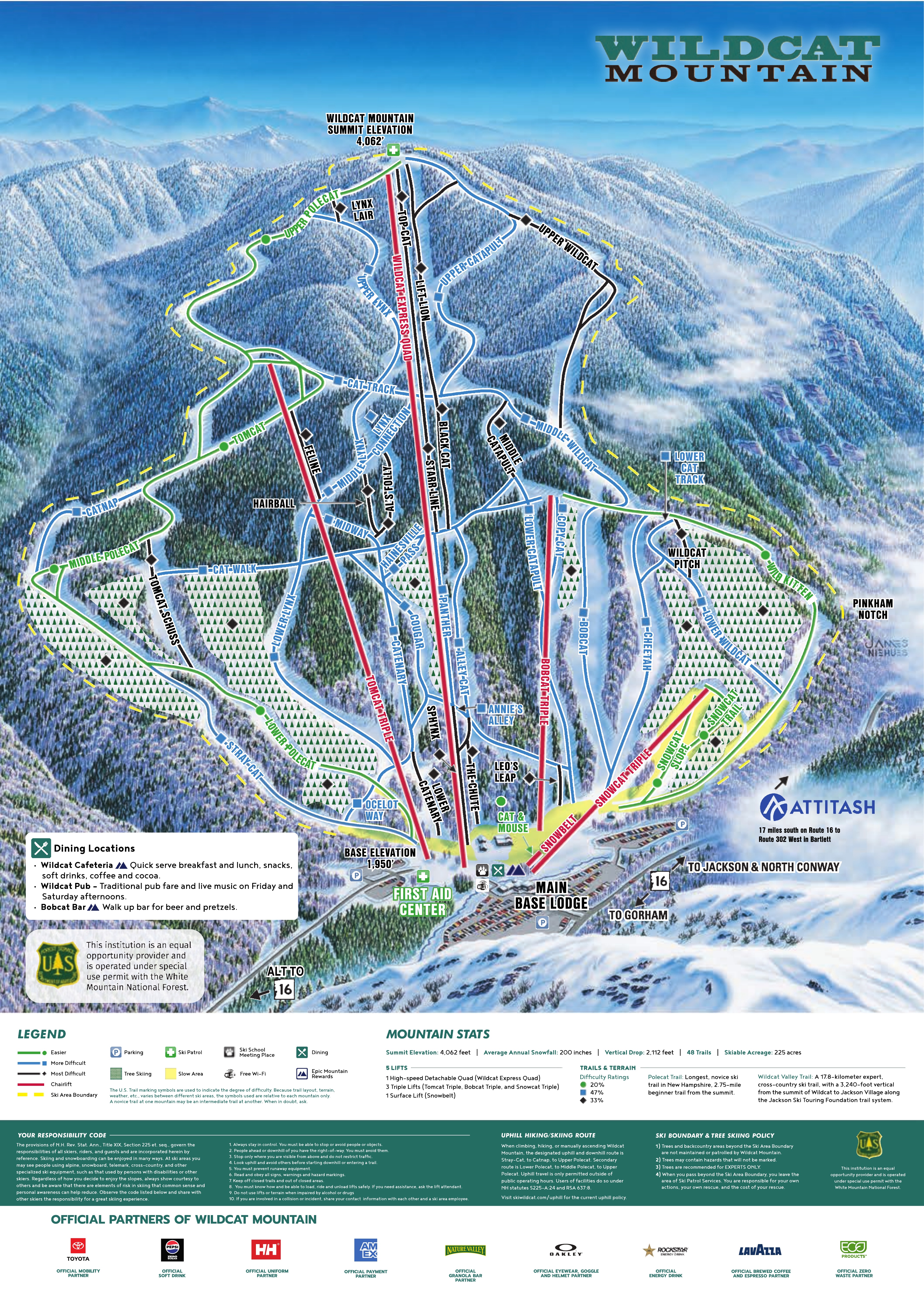
Wildcat Mountain Ski Area is a ski area located on Wildcat Mountain near Jackson, New Hampshire, United States, in the Mount Washington Valley. Its vertical drop of 2,112 feet (644 m) is the second largest in New Hampshire and the ninth largest in New England.
More about Wildcat
Wildcat is one of the best-known alpine skiing resorts in New England, with lifts from the base on NH 16 in Pinkham Notch 2,112 feet (644 m) up to the summit ridge. The area has 49 trails on 225 acres (91 ha), including the 2.75-mile (4.43 km) Polecat Trail — the longest ski trail in New Hampshire.
The Wildcat Valley Trail, an ungroomed cross-country ski trail, leads from the summit down to the town of Jackson, New Hampshire as part of the Jackson Ski Touring Foundation trail network, dropping 3,240 feet (990 m) in 11.1 miles (17.9 km).
From Wikipedia: Wildcat Mountain Ski Area, CC BY-SA 4.0.
Ski area
Figures for the ski area as mapped: Wildcat Mountain.
- Green 4.7 mi
- Blue 7.6 mi
- Black 3.6 mi
Counted from the runs and lifts mapped in OpenStreetMap, by OpenSkiMap; © OpenStreetMap contributors. Resorts count their own way (trails, acres), so their figures can differ.
Road and nearby webcams
windy.com
Getting there
Nearby resorts
Ask Claude or ChatGPT "Is Wildcat open today?" with status.live connected. How to connect