Hintertux Glacier
17 of 21 lifts running
Most on Thu 26, 6 cm · Snow to the base · Upper mountain
- Today22Snow showers3 cm4°-1°
- Tomorrow23Snow grains1 cm-1°-5°
- Tue24Cloudy20% chance1°-6°
Daily forecast · 7 more days
- Wed25Light rain2 cm4°0°
- Thu26Snow grains6 cm2°-6°Snow to the base
- Fri27Fog46% chance-3°-8°
- Sat28Partly cloudy1°-8°
- Sun29Cloudy5°-4°
- Mon30Fog22% chance0°-9°
- Tue1Fog27% chance1°-10°
Forecast: Open-Meteo (CC BY 4.0) · snow depth: avalanche.report
Checked at 10:52 PM · 10:52 PM local time · from winter.intermaps.com
Hintertux Glacier webcams
Map
Maps
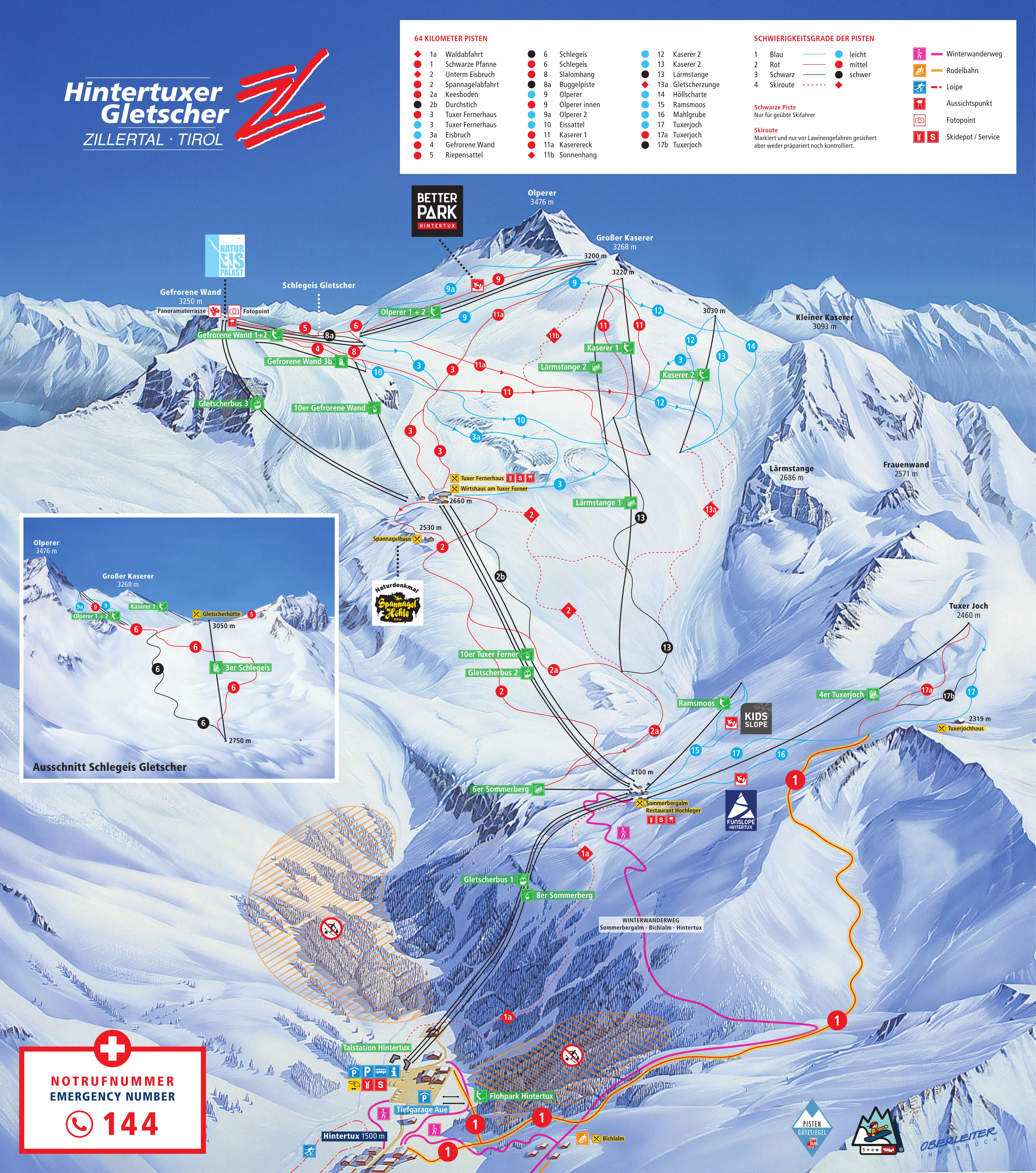
3D map beta
Shows where you are on the mountain
Vertical drop: 1,745 m verticalBase 1,500 · Top 3,245 m#29 of 318 on status.live
Getting there
Road and nearby webcams3
Source: windy.com
Hintertux Glacier lift status
17 of 21 openOpen · 17
- 6er SommerbergOpen
- 6er Lärmstange 1Open
- 6er Lärmstange 2Open
- Gefrorene Wand 1Open
- Gefrorene Wand 2Open
- Olperer 1Open
- Kaserer 1Open
- Kaserer 2Open
- RamsmoosOpen
- Olperer 2Open
- Babylift GletscherbodenOpen
- Gletscherbus 1Open
- Gletscherbus 2Open
- Gletscherbus 3Open
- 8er SommerbergOpen
- 4er FernerhausOpen
- 10 EUB Gefrorene WandOpen
4 closedShow
- 2er Gefrorene Wand 3bClosed
- 3er SchlegeisClosed
- 4erTuxerjochClosed
- Babylift HintertuxClosed
Source: winter.intermaps.com, the resort's own lift board, checked every few minutes.
Runs
13 of 32 open · 45.5 of 80.5 kmOpen · 13
- Run 3BlueOpen
- 9 Olperer 1Blue3.5 kmOpen
- 9a Olperer 2Blue2.0 kmOpen
- Run 10BlueOpen
- 12 HöllscharteBlue8.0 kmOpen
- 15 RamsmoosBlue1.0 kmOpen
- 2 SpannagelabfahrtRed4.5 kmOpen
- 3 Tuxer FernerhausRed8.0 kmOpen
- 5 RiepensattelRed5.0 kmOpen
- 8 SlalomhangRed4.5 kmOpen
- 9 Olperer innenRedOpen
- 11 KasererRed6.0 kmOpen
- 11a KaserereckRed3.0 kmOpen
19 closedShow
- Run 3aBlueClosed
- Run 13BlueClosed
- Run 14BlueClosed
- 16 MahlgrubeBlue3.0 kmClosed
- 17 TuxerjochBlue5.0 kmClosed
- 1 Schwarze PfanneRed7.0 kmClosed
- 2a MoräneRed3.0 kmClosed
- 4 Gefrorene WandRedClosed
- 6 SchlegeisRedClosed
- 17a TuxerjochRed0.5 kmClosed
- Run 2bBlackClosed
- 6 SchlegeisBlackClosed
- 8a BugglpisteBlack1.0 kmClosed
- Bergtour ZittauerhütteBlackClosed
- 1a WaldabfahrtSki route3.0 kmClosed
- 2 Unterm EisbruchSki route3.0 kmClosed
- 11b SonnenhangSki route1.0 kmClosed
- 13 GletscherzungeSki route5.0 kmClosed
- 13a HaxenbrecherSki route3.5 kmClosed
Same source and update time as the lifts above.
About Hintertux Glacier
History, runs and liftsShow
About
The Hintertux Glacier (German: Hintertuxer Gletscher) is the tourist name for the glaciers of the Gefrorene-Wand-Kees, also called the Tuxer Ferner, and the nearby Riepenkees at the top of the Tuxertal, a side valley of the Zillertal in the Austrian state of Tyrol. At its highest point the ski region reaches a height of 3,250 m (10,660 ft) in the saddle between the peaks of the Gefrorene-Wand-Spitzen.
More about Hintertux Glacier
Both glaciers can be accessed by gondola and chair lifts.
From Wikipedia: Hintertux Glacier, CC BY-SA 4.0.
Ski area
Figures for the ski area as mapped: Hintertuxer Gletscher.
- Blue 17 km
- Red 25 km
- Black 2.9 km
- Other 1.2 km
Counted from the runs and lifts mapped in OpenStreetMap, by OpenSkiMap; © OpenStreetMap contributors. Resorts count their own way (trails, acres), so their figures can differ.
Reviews
No reviews yet.
Nearby resorts
Ask Claude or ChatGPT "Is Hintertux Glacier open today?" with status.live connected. How to connect