Sierra at Tahoe
None of 14 lifts running right now
Most on Wed 18, 18 in · Rain at the base Wed 25 · Upper mountain · Full forecast
Checked at 4:07 AM · 4:07 AM local time · from sierraattahoe.com
Map
Maps
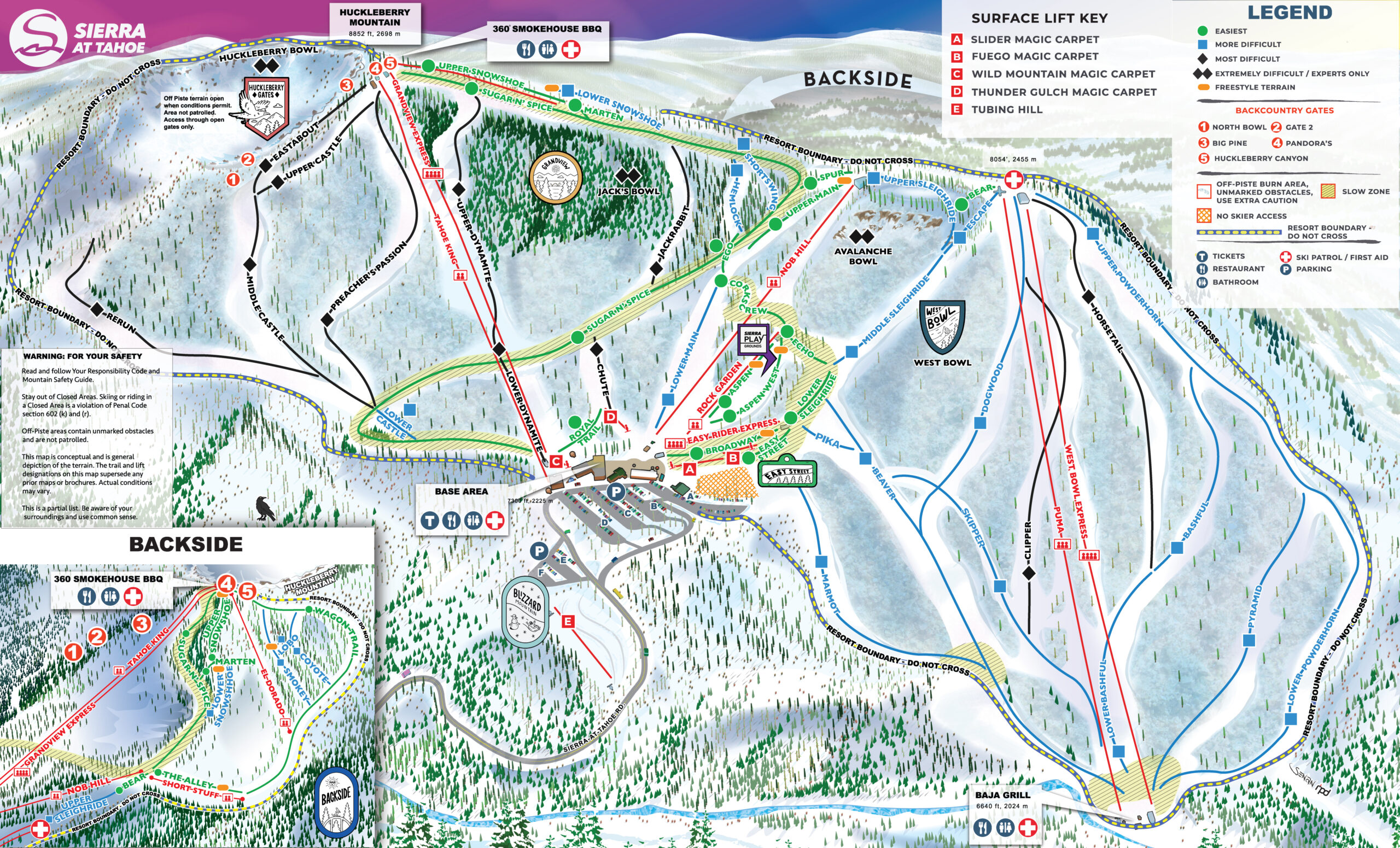
3D map beta
Shows where you are on the mountain
Vertical drop: 2,175 ft verticalBase 6,660 · Top 8,835 ft#206 of 318 on status.live
Sierra at Tahoe snow report and forecast
Snow depth measured by USDA NRCS SNOTEL (public domain) at its Echo Peak station, 6.3 km from the resort, today; snow on a flat field there, not on the pistes. Other snow figures are a model estimate.
- Today17Light snow28°18°
- Tomorrow18Heavy snow18 in34°18°Snow to the base
- Thu19Heavy snow16 in32°21°Snow to the base
- Fri20Fog72%30°10°
- Sat21Heavy snow3 in32°10°Snow to the base
- Sun22Heavy snow8 in30°12°Snow to the base
- Mon23Snow showers1 in32°12°Snow to the base
- Tue24Snow showers6 in36°28°Snow to the base
- Wed25Snow showers16 in36°30°Rain at the base until about 1 pm, then snow
- Thu26Snow showers2 in34°28°Snow to the base
Source: Open-Meteo (CC BY 4.0), model forecast; temperatures and conditions are for the base, 6,644 ft, snow for the upper mountain, 8,855 ft.
Roads
checked 4:05 AM- US-50no chain controls
- SR-89R-2 · Chains or traction devices are required on all vehicles except four wheel / all wheel drive vehicles with snow-tread tires on all four wheels. Four wheel / all wheel drive vehicles must carry traction devices in chain control areas.
Source: Caltrans chain controls
Sierra at Tahoe lift status
6,644 ft–8,855 ftAll 14 lifts closedShow
- Easy Rider ExpressClosed
- Grandview ExpressClosed
- Rock GardenClosed
- Tahoe KingClosed
- Thunder Gulch Carpet (Ski/Ride School Only)Closed
- Blizzard Mountain TubingClosed
- Fuego CarpetClosed
- Nob HillClosed
- Slider CarpetClosed
- Wild Mountain Carpet (Ski/Ride School Only)Closed
- El DoradoClosed
- Short StuffClosed
- West Bowl ExpressClosed
- PumaClosed
Source: sierraattahoe.com, the resort's own lift board, checked every few minutes.
About
Sierra-at-Tahoe is a ski and snowboard resort in Twin Bridges, California south of Lake Tahoe. Sierra-at-Tahoe is approximately 16 miles (26 km) south of Stateline, Nevada and 12 miles (19 km) south of South Lake Tahoe on U.S. Route 50 and is contained within the Eldorado National Forest.
More about Sierra at Tahoe
Sierra-at-Tahoe (often shortened to "Sierra") is a medium-sized ski area in the Lake Tahoe region, and is well known for being a more family oriented resort and also having a high annual snowfall. Sierra-at-Tahoe's terrain is 25 percent beginner, 50 percent Intermediate, and 25 percent advanced.
The majority of the ski resorts in the Lake Tahoe region are on the northern end of the lake, near Truckee, California and Reno, Nevada. Sierra-at-Tahoe, Kirkwood and Heavenly are located south of the lake, approximately 75 miles (120 km) from Reno.
From Wikipedia: Sierra-at-Tahoe, CC BY-SA 4.0.
Ski area
Figures for the ski area as mapped: Sierra-at-Tahoe Ski Resort.
- Green 7.0 mi
- Blue 5.8 mi
- Black 4.1 mi
Counted from the runs and lifts mapped in OpenStreetMap, by OpenSkiMap; © OpenStreetMap contributors. Resorts count their own way (trails, acres), so their figures can differ.
Road and nearby webcams
Caltrans
Getting there
Nearby resorts
Ask Claude or ChatGPT "Is Sierra at Tahoe open today?" with status.live connected. How to connect