Light snow Wednesday, then a dry Thanksgiving
Generated automatically by status.live from weather models and the National Weather Service, and written by an AI model from those sources. Not reviewed by a meteorologist.
Auf einen Blick
Snow above about 4,700 ft when it starts Wed early morning, rising to about 5,800 ft by Wed 8 am. Heaviest Wed early morning.
- HomewoodSchnee am Berg4 inauf 7,884 ftModelle, oben0–4 inIm Tal4 inauf 6,243 ftSchnee
- Palisades TahoeSchnee am Berg3 inauf 8,750 ftModelle, oben0–3 inIm Tal3 inauf 6,198 ftSchnee
- Alpine MeadowsSchnee am Berg3 inauf 8,494 ftModelle, oben0–4 inIm Tal3 inauf 6,224 ftSchnee
- KirkwoodSchnee am Berg3 inauf 9,469 ftModelle, oben0–4 inIm Tal3 inauf 7,812 ftSchnee
- Sierra at TahoeSchnee am Berg3 inauf 8,855 ftModelle, oben0–3 inIm Tal3 inauf 6,644 ftSchnee
- Sugar BowlSchnee am Berg2 inauf 8,369 ftModelle, oben0–4 inIm Tal2 inauf 6,873 ftSchnee
- Donner Ski RanchSchnee am Berg2 inauf 7,756 ftModelle, oben0–4 inIm Tal2 inauf 7,037 ftSchnee
- BorealSchnee am Berg2 inauf 7,700 ftModelle, oben0–2 inIm Tal2 inauf 7,169 ftSchnee
- Tahoe DonnerSchnee am Berg2 inauf 7,280 ftModelle, oben0–2 inIm Tal2 inauf 6,791 ftSchnee
- NorthstarSchnee am Berg2 inauf 8,612 ftModelle, oben0–2 inIm Tal2 inauf 6,302 ftSchnee
- HeavenlySchnee am Berg2 inauf 9,964 ftModelle, oben0–2 inIm Tal2 inauf 6,283 ftSchnee
- Mount RoseSchnee am Berg1 inauf 9,567 ftModelle, oben0–1 inIm Tal1 inauf 7,936 ftSchnee
- Diamond PeakSchnee am Berg1 inauf 8,524 ftModelle, oben0–2 inIm Tal1 inauf 6,732 ftSchnee
A weak storm brings light snow to Tahoe resorts early Wednesday, Nov 25, with only 1 to 4 inches up top. The bottom line for skiers: snow reaches all bases, but amounts are small and most resorts are not yet open for the season.
Regen oder Schnee
Snow starts above about 4,700 feet early Wednesday morning, then snow levels rise to about 5,800 feet by 8 am. The National Weather Service in Reno says snow levels lift from 5,000 to 5,500 feet to near 7,000 feet during the storm, so a switch from snow to rain is possible below Sierra passes sometime Wednesday. All listed bases are high enough to stay snow in the table, but amounts are light.
Sturmsummen oben
Confidence is moderate for a weak storm Wednesday. The National Weather Service in Reno says the storm has trended much weaker in latest guidance, with a 70 percent chance of 2 to 3 inches along the Sierra crest and 70 to 90 percent chance of 1 to 2 inches at pass level. Models disagree on exact totals, with some showing no snow at all.
- Homewood4 in0 in bis 4 in
- Palisades Tahoe3 in0 in bis 3 in
- Alpine Meadows3 in0 in bis 4 in
- Kirkwood3 in0 in bis 4 in
- Sierra at Tahoe3 in0 in bis 3 in
- Sugar Bowl2 in0 in bis 4 in
- Donner Ski Ranch2 in0 in bis 4 in
- Boreal2 in0 in bis 2 in
- Tahoe Donner2 in0 in bis 2 in
- Northstar2 in0 in bis 2 in
- Heavenly2 in0 in bis 2 in
- Mount Rose1 in0 in bis 1 in
- Diamond Peak1 in0 in bis 2 in
Balken: unsere Prognose, wie auf der Seite jedes Skigebiets. Linie: tiefster bis höchster Wert des europäischen, amerikanischen und deutschen Modells.
Wind
Keine Böen ab 40 mph oben in der Prognose.
- Northstar23 mphMi 2 Uhr
- Mount Rose23 mphMi 2 Uhr
- Diamond Peak23 mphMi 2 Uhr
- Kirkwood17 mphMi 2 Uhr
- Sierra at Tahoe17 mphMi 2 Uhr
- Heavenly17 mphMi 2 Uhr
- Homewood17 mphMi 2 Uhr
- Palisades Tahoe10 mphMi 2 Uhr
- Alpine Meadows10 mphMi 2 Uhr
- Sugar Bowl10 mphMi 2 Uhr
- Donner Ski Ranch10 mphMi 2 Uhr
- Boreal10 mphMi 2 Uhr
- Tahoe Donner10 mphMi 2 Uhr
Stärkste Böe an der Bergstation jedes Skigebiets während des Sturms, aus unserer Prognose, 10 m über Grund. Exponierte Grate können stärker böig sein. Viele Skigebiete drosseln oder stoppen exponierte Lifte ab etwa 40 mph; jedes setzt eigene Grenzen. Zeiten: solange Böen bei 40 mph oder mehr bleiben; darunter die Stunde der stärksten Böe.
Strassen und Lifte
No chain controls or traction laws are currently listed. The National Weather Service in Reno expects minor travel impacts in the Sierra through tonight, then the most ideal holiday travel window Monday into Tuesday afternoon. Boreal has 4 of 8 lifts open; all other listed resorts are not yet open for the season. Upper gusts stay below 25 mph Wednesday, so wind holds are unlikely.
Nächste Woche
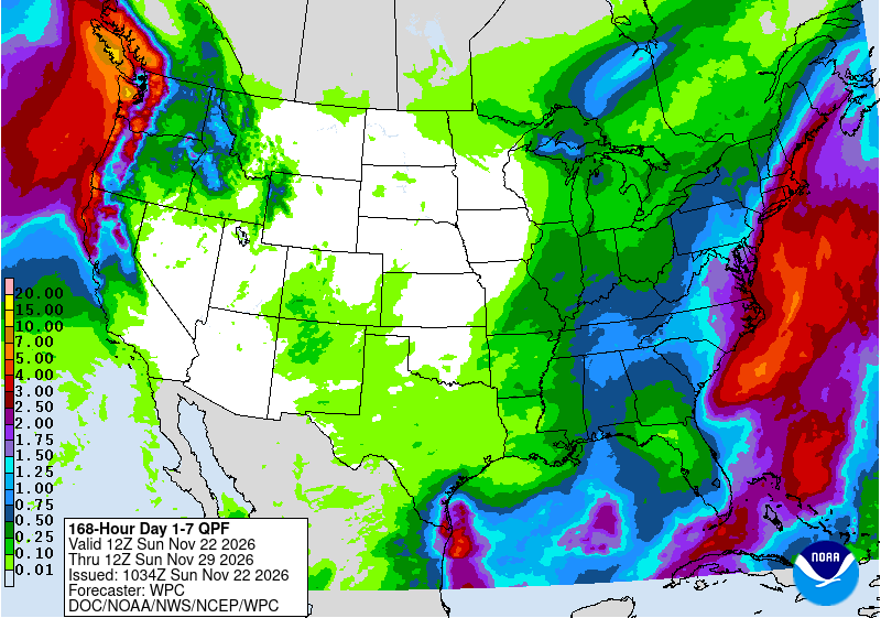
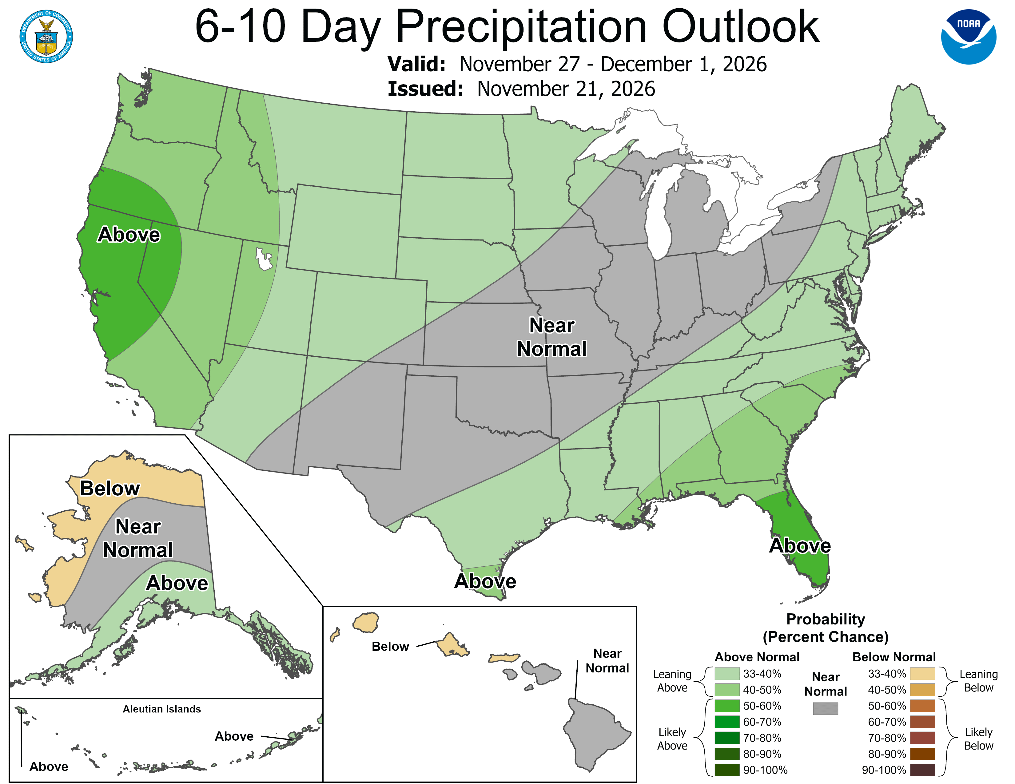
Dry and mild weather is favored for Thanksgiving Day and Friday. NOAA's Climate Prediction Center shows a transitioning pattern for Nov 27 to Dec 1, with low confidence and models in fair agreement at best; additional storms are possible next weekend, Nov 28 to 29.
 Tap to enlarge
 Tap to enlarge
Weitere Stürme: Tahoe
Sources: model data from Open-Meteo (CC BY 4.0), with rain or snow worked out by status.live from the wet-bulb temperature at each resort's base and top lifts. Discussion: National Weather Service. Maps: NOAA WPC and CPC. Satellite: NOAA GOES-West via NASA GIBS. Lifts and chain controls: status.live, from the resorts and road agencies. Earlier storms.