Light snow Wednesday, then a dry Thanksgiving
Generated automatically by status.live from weather models and the National Weather Service, and written by an AI model from those sources. Not reviewed by a meteorologist.
En bref
Snow above about 4,700 ft when it starts Wed early morning, rising to about 5,800 ft by Wed 8 am. Heaviest Wed early morning.
- HomewoodNeige en haut4 inà 7,884 ftModèles, en haut0–4 inEn bas4 inà 6,243 ftNeige
- Palisades TahoeNeige en haut3 inà 8,750 ftModèles, en haut0–3 inEn bas3 inà 6,198 ftNeige
- Alpine MeadowsNeige en haut3 inà 8,494 ftModèles, en haut0–4 inEn bas3 inà 6,224 ftNeige
- KirkwoodNeige en haut3 inà 9,469 ftModèles, en haut0–4 inEn bas3 inà 7,812 ftNeige
- Sierra at TahoeNeige en haut3 inà 8,855 ftModèles, en haut0–3 inEn bas3 inà 6,644 ftNeige
- Sugar BowlNeige en haut2 inà 8,369 ftModèles, en haut0–4 inEn bas2 inà 6,873 ftNeige
- Donner Ski RanchNeige en haut2 inà 7,756 ftModèles, en haut0–4 inEn bas2 inà 7,037 ftNeige
- BorealNeige en haut2 inà 7,700 ftModèles, en haut0–2 inEn bas2 inà 7,169 ftNeige
- Tahoe DonnerNeige en haut2 inà 7,280 ftModèles, en haut0–2 inEn bas2 inà 6,791 ftNeige
- NorthstarNeige en haut2 inà 8,612 ftModèles, en haut0–2 inEn bas2 inà 6,302 ftNeige
- HeavenlyNeige en haut2 inà 9,964 ftModèles, en haut0–2 inEn bas2 inà 6,283 ftNeige
- Mount RoseNeige en haut1 inà 9,567 ftModèles, en haut0–1 inEn bas1 inà 7,936 ftNeige
- Diamond PeakNeige en haut1 inà 8,524 ftModèles, en haut0–2 inEn bas1 inà 6,732 ftNeige
A weak storm brings light snow to Tahoe resorts early Wednesday, Nov 25, with only 1 to 4 inches up top. The bottom line for skiers: snow reaches all bases, but amounts are small and most resorts are not yet open for the season.
Pluie ou neige
Snow starts above about 4,700 feet early Wednesday morning, then snow levels rise to about 5,800 feet by 8 am. The National Weather Service in Reno says snow levels lift from 5,000 to 5,500 feet to near 7,000 feet during the storm, so a switch from snow to rain is possible below Sierra passes sometime Wednesday. All listed bases are high enough to stay snow in the table, but amounts are light.
Cumuls de la tempête en haut
Confidence is moderate for a weak storm Wednesday. The National Weather Service in Reno says the storm has trended much weaker in latest guidance, with a 70 percent chance of 2 to 3 inches along the Sierra crest and 70 to 90 percent chance of 1 to 2 inches at pass level. Models disagree on exact totals, with some showing no snow at all.
- Homewood4 in0 in à 4 in
- Palisades Tahoe3 in0 in à 3 in
- Alpine Meadows3 in0 in à 4 in
- Kirkwood3 in0 in à 4 in
- Sierra at Tahoe3 in0 in à 3 in
- Sugar Bowl2 in0 in à 4 in
- Donner Ski Ranch2 in0 in à 4 in
- Boreal2 in0 in à 2 in
- Tahoe Donner2 in0 in à 2 in
- Northstar2 in0 in à 2 in
- Heavenly2 in0 in à 2 in
- Mount Rose1 in0 in à 1 in
- Diamond Peak1 in0 in à 2 in
Barre : notre prévision, comme sur la page de chaque station. Trait : du plus bas au plus haut des modèles européen, américain et allemand.
Vent
Pas de rafales de 40 mph en haut dans la prévision.
- Northstar23 mphmer. 2 h
- Mount Rose23 mphmer. 2 h
- Diamond Peak23 mphmer. 2 h
- Kirkwood17 mphmer. 2 h
- Sierra at Tahoe17 mphmer. 2 h
- Heavenly17 mphmer. 2 h
- Homewood17 mphmer. 2 h
- Palisades Tahoe10 mphmer. 2 h
- Alpine Meadows10 mphmer. 2 h
- Sugar Bowl10 mphmer. 2 h
- Donner Ski Ranch10 mphmer. 2 h
- Boreal10 mphmer. 2 h
- Tahoe Donner10 mphmer. 2 h
Rafale la plus forte au sommet de chaque station pendant la tempête, selon notre prévision, à 10 m du sol. Les crêtes exposées peuvent souffler plus fort. Beaucoup de stations ralentissent ou arrêtent les remontées exposées dès 40 mph environ ; chacune fixe ses propres limites. Horaires : tant que les rafales restent à 40 mph ou plus ; en dessous, l’heure de la plus forte.
Routes et remontées
No chain controls or traction laws are currently listed. The National Weather Service in Reno expects minor travel impacts in the Sierra through tonight, then the most ideal holiday travel window Monday into Tuesday afternoon. Boreal has 4 of 8 lifts open; all other listed resorts are not yet open for the season. Upper gusts stay below 25 mph Wednesday, so wind holds are unlikely.
La semaine prochaine
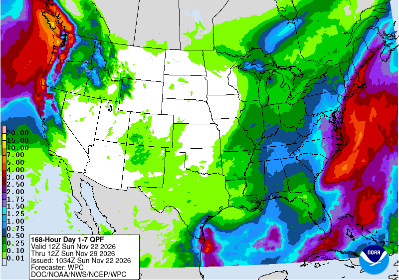
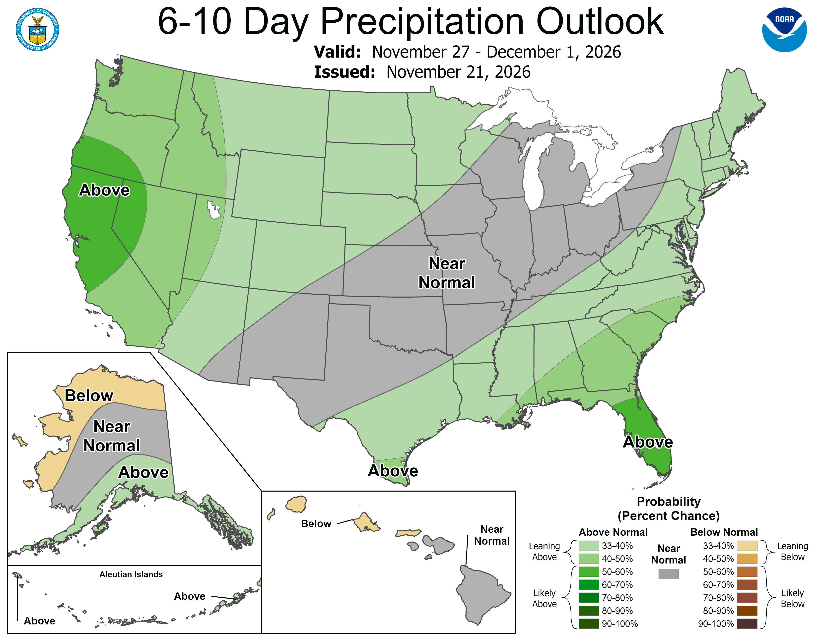
Dry and mild weather is favored for Thanksgiving Day and Friday. NOAA's Climate Prediction Center shows a transitioning pattern for Nov 27 to Dec 1, with low confidence and models in fair agreement at best; additional storms are possible next weekend, Nov 28 to 29.
 Tap to enlarge
 Tap to enlarge
Autres tempêtes : Tahoe
Sources: model data from Open-Meteo (CC BY 4.0), with rain or snow worked out by status.live from the wet-bulb temperature at each resort's base and top lifts. Discussion: National Weather Service. Maps: NOAA WPC and CPC. Satellite: NOAA GOES-West via NASA GIBS. Lifts and chain controls: status.live, from the resorts and road agencies. Earlier storms.